Entry Points:

About Yosemite Valley
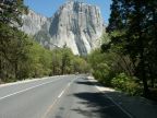
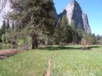
Standing in the El Capitan meadows, at the center of Yosemite Valley, a pristine grassland stretches from the banks of the Merced River for about a quarter mile to the forests growing along Northside Drive. A few coniferous trees line the river and dot the center of the meadow. Along the road, a row of light green deciduous trees contrast the darker and taller coniferous trees behind them. Behind these rises a wall of light-colored granite, smooth and almost vertical, dwarfing the hundred-foot-tall trees and reaching 3000 feet into the sky above. Known as El Capitan, this monolith is famous around the world for its size and sheer face. Across the river, the triangular faces of the Cathedral Rocks form the opposite wall of the valley, rising from forests at their base.
Yosemite Valley stretches for about six miles, lined on both sides by towering cliffs. Other features along them have been given names like Sentinel Rock, Panorama Cliff, Three Brothers, Eagle Tower, North Dome and Half Dome. Half Dome, with its rounded outline, and vertical face, lies at the upper end of the valley, puncuating the valley with its most beautiful monument.
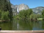
In the springtime, winter snow melts off the higher mountains around the valley, and cascade off the cliffs in several beautiful and impressive waterfalls: Bridalveil Fall, Ribbon Fall, Sentinel Fall, Staircase Falls and Yosemite Falls. Later in the season, when the snow is melted, the falls dwindle in size, and some dry up completely.
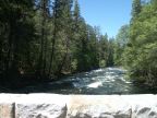
The Merced River flows the length of the valley; the Northside Drive parallels it on the north, and Southside Drive parallels it on the south. The two routes combine at the west end of the valley, and follow the Merced River as it descends through the Merced Gorge, with the name of El Portal Road. Not too far down the gorge, Big Oak Flat Road takes off on the north and climbs the wall of the canyon, passing through three tunnels to reach the rim, and leads to park exits both on the east and west sides of the park. Wawona Road intersects Southside Drive, and it also climbs the canyon wall, passing through a mile-long tunnel, and then heads southward out of the park.
Large numbers of visitors come to Yosemite Valley annually, and many accomodations have been provided, including a hotel, lodge, campgrounds and picnic areas. There are numerous bicycle and foot paths and hiking trails. Several trails ascend the valley walls, including the Four Mile Trail (leading to wonderful views from Glacier Point) and the Yosemite Falls Trail. The Valley Loop Trail parallels Northside and Southside Drives, with many access points, providing a less strenuous hike through the forests lining the base of the cliffs.