Entry Points:

About Tenaya Lake
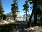
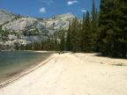
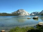
Tenaya Lake lies nestled among the granite peaks of the Sierra Nevadas near the center of Yosemite National Park. Nearly a mile long, the blue waters of the lake reflect the surrounding evergreen forests and white-domed mountain sides. A beautiful sandy beach borders the lake at the eastern end and a granite dome rises from the northeast corner of the lake. Westward, the northern shore widens out, with exposed granite along the lakeshore, and trees further back. A forested mountain slope rises from the southern shore, with boulders scattered about its face, both above the water, and visible through the clear water at the bottom of the lake.
At the west end of the lake, Tenaya Creek flows out through a patchwork of forest and grassland. About a mile to the south the creek begins a series of dramatic descents that bring it into Tenaya Canyon and eventually the Yosemite Valley.
Pywiack Dome stands to the east of Tenaya Lake and beautiful views of it can be seen across the lake from the southwestern corner.
At 8150 feet in elevation, Tenaya Lake is a popular retreat from hot summer days where families bring their children to swim in the cool waters. It is named after a legendary Indian Chief whose people had lived in Yosemite Valley. When an illness devastated their tribe, his father fled to the Mono Basin where Tenaya lived with his mother's people. Hearing the stories of the "deep and grassy valley", he crossed the Sierras and established the Ahwahneechee tribe who inhabited the valley in historic times.
Tioga Road passes right along the northern shore, providing easy access to the lake. A foot trail passes along the southern shore, connected to the road at the ends of the lake by intersecting trails.
Street Index
|
a road a shore a trail |
Murphy Creek Trail Tenaya Lake Tioga Road |